Tornado outbreaks
Four state Tornado swarm
This outbreak was the first destructive tornado outbreak that occurred on August 15, 1787 during the ratification of the constitution At least five separate tornadoes caused major damage in the states of Connecticut, Rhode Island, Massachusetts, and New Hampshire. Two people were killed by a tornado in Wethersfield, Connecticut, and many were injured throughout New England. This event is considered to be the first true tornado outbreak on record.
This outbreak was the first destructive tornado outbreak that occurred on August 15, 1787 during the ratification of the constitution At least five separate tornadoes caused major damage in the states of Connecticut, Rhode Island, Massachusetts, and New Hampshire. Two people were killed by a tornado in Wethersfield, Connecticut, and many were injured throughout New England. This event is considered to be the first true tornado outbreak on record.
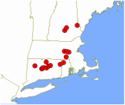
Cities and towns that reported damage. not every dot represents a tornado as some tornadoes struck more than one town
Great Natchez Tornado
The Great Natchez tornado was the second deadliest tornado outbreak on record with over 320 casualties. Since there was no Fujita scale at the time this tornado remains uncategorized.
The massive tornado formed southwest of Natchez, shortly before 1 p.m., and moved northeast along the Mississippi River. It followed the river directly, stripping forests from both shores. The vortex then struck the riverport of Natchez Landing, located below the bluff from Natchez. This windstorm tossed 60 flatboats into the river, drowning their crews and passengers. Other boats were picked up and thrown onto land. A piece of a steamboat window was reportedly found 30 miles (50 km) from the river. Many doing business onshore were also killed. At Natchez Landing, the destruction of dwellings, stores, steamboats and flatboats was almost complete. It then moved into the town of Natchez, though its full width of devastation also included the river and the Louisiana village of Vidalia, across the river. Witnesses reported that "the air was black with whirling eddies of walls, roofs, chimneys and huge timbers from distant ruins...all shot through the air as if thrown from a mighty catapult." The central and northern portions of Natchez were slammed by the funnel and many buildings were completely destroyed. 48 people were killed on land, and 269 others were killed on the river.
The final death toll was 48 on land (with 47 deaths in Natchez and one in Vidalia) and 269 on the river, mostly from the sinking of flatboats. In addition to the 317 deaths, only 109 were injured, a testament to the tornado's intensity. The tornado is to this day ranked as the second deadliest in American history, and caused $1,260,000 in damage. The actual death toll may be higher than what is listed, as slave deaths were often not counted during this time period.
1881 Hopkins Tornado
This was a tornado that occurred on June 12, 1881 near Hopkins Missouri. although there were originally eight tornadoes, four of the tornadoes are believed to have come together to create a very large tornado which is extremely unusual. this tornado was one of the first F5 tornadoes in recorded history according to Thomas P. Grazulis
This was a tornado that occurred on June 12, 1881 near Hopkins Missouri. although there were originally eight tornadoes, four of the tornadoes are believed to have come together to create a very large tornado which is extremely unusual. this tornado was one of the first F5 tornadoes in recorded history according to Thomas P. Grazulis
1883 Rochester Tornado
This tornado was an F5 tornado that struck Rochester Minnesota. This tornado was part of a larger outbreak that was in the northern plains which killed 37 people and caused over 200 casualties. This tornado outbreak facilitated the creation of the Mayo Clinic. After the tornado chaos ensued as the city did not have enough hospitals to treat the wounded
Although meteorology at the time was inadequate, it marked the first time that scientists noted the conditions before the storm hit. This would be the predecessor of weather forecasting. Due to the devastation of the Rochester tornado most of the other tornadoes were largely ignored
1925 Tri-State tornado
The 1925 Tri state tornado was the deadliest tornado in american history with 695 confirmed deaths which is twice of the Great Natchez Tornado. The 235 mile long track was the longest in the world as it traveled. it is the most recognized tornado in a major outbreak of 12+ significant tornadoes
Total 12
F0 0
F1 0
F2 2
F3 4
F4 2
F5 1
This tornado was part of a larger outbreak of other significant tornadoes in Tennessee,Kentucky and Indiana. At least 747 people were killed in the outbreak and there were 2298 injuries making March 18 the deadliest tornadic day in history. There were most likely many more tornadoes which their occurrence has been lost to history.
Track of the Tri-State Tornado in the "Monthly Weather Report"
Public Domain image
Public Domain image
1932 Deep South tornado outbreak
One of the most intense outbreaks in US history, produced 10 violent tornadoes. Third-deadliest continuous tornado outbreak in US history. Hundreds of people were killed by violent tornadoes across the Southern United States. Deadliest Alabama outbreak with 268 fatalities.
Total at least 36
F0 ?
F1 ?
F2 16
F3 10
F4 10
F5 0
Total at least 36
F0 ?
F1 ?
F2 16
F3 10
F4 10
F5 0
1936 Tupelo Gainsville tornado outbreak
Second-deadliest continuous tornado outbreak in US history. Several strong and deadly tornadoes were observed across the South. Two of the individual tornadoes killed well over 200 people each. Total fatalities were over 450
F0 ?
F1 ?
F2 2
F3 7
F4 2
F5 1
Tupelo tornado
Ground Zero of this tornado outbreak was this tornado. making it's way to the city, this devastating tornado killed a family of 13 and injured many more as it made it's way to the west side of Tupelo. Retroactively this tornado was rated as an F5 on the Fujita Scale. it caused total devastation as it crossed into several neighborhoods. Dozens of mansions that were well built were completely destroyed. reports stated that the winds were so powerful that pine needles were driven into tree trunks. The tornado destroyed a water tower and ruptured gas lines that caused numerous fires all over the city though they were contained by flooding rains overnight.
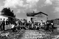
Search and rescue teams searching for bodies after the tornado
Courtesy of New Deal Network at Columbia University
Courtesy of New Deal Network at Columbia University
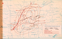
1947 Glazier-Higgins-Woodward tornadoes
The 1947 Glazier-Higgins-Woodward tornadoes were a system of deadly tornadoes that struck Texas Oklahoma and Kansas. Most of the damage and deaths that occurred are largely blamed on a single F5 tornado that traveled at least 120 miles from Texas to Oklahoma. this tornado was often compared to the Tri-State tornado as the path was over 220 miles, but now it is believed to be a family of 8 or 9 tornadoes. Although significant these tornadoes were not nearly outstanding as the Tri- State-tornado nor did they match the speed of the earlier tornado. Although they traveled at 40 MPH they qualified as fast moving tornadoes
Complicating recovery efforts was a winter storm that struck the region 12 hours later.
Complicating recovery efforts was a winter storm that struck the region 12 hours later.
The storm system associated with the tornadoes
courtesy of Stormstalker.wordpress.com
1953 Waco tornado outbreak
The Waco tornado was a deadly tornado that struck the city of Waco Texas. The tornado was over two blocks wide as it crashed into downtown Waco.
Many people were caught off guard when the tornado struck as there was very heavy rain obscuring the tornado. Many people also believed in an old urban legend that tornadoes cannot strike downtown areas. This tornado was the tenth deadliest tornado in american history
Total
33
F0 3
F1 13
F2 7
F3 4
F4 5
F5
Flint-Worcester tornadoes
The Flint-Worcester tornadoes were a series of devastating tornado outbreaks that pasted for three days. Two of the tornadoes were especially deadly with each of them causing 90 fatalities. The first tornado was an F5 that struck Flint, Michican while the second tornado was an F4 that struck Worcester Massachusetts
The tornadoes are among the deadliest in history and were caused by the same weather system traveling in an eastward direction. For a brief period, it was debated whether nuclear testing in the pacific ocean had any profound affect on the weather as it was speculated by scientists at the time that radiation could affect the atmosphere.
The tornadoes are among the deadliest in history and were caused by the same weather system traveling in an eastward direction. For a brief period, it was debated whether nuclear testing in the pacific ocean had any profound affect on the weather as it was speculated by scientists at the time that radiation could affect the atmosphere.
The F5 Worcester tornado as it was approaching the city
1965 Palm Sunday tornado outbreak
This outbreak occurred on Palm Sunday and impacted states such as Indiana, Ohio, Michigan, Wisconsin, Illinois and Iowa. At the time in 1965 it was the second biggest outbreak ever. It was also one of the deadliest tornado outbreaks on record with 271 deaths with 137 of those deaths in Indiana alone.The outbreak also made that week in April 1965 the second-most-active week in history, with 51 significant and 21 violent tornadoes. Despite having 17 F4 tornadoes, 6 of them (4 in Indiana, and 2 in Ohio) are questionable, and may have been F5's.
Total 47
F0 0
F1 15
F2 10
F3 5
F4 17
F5 0
Total 47
F0 0
F1 15
F2 10
F3 5
F4 17
F5 0
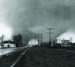
The "double tornado" as it hit the Midway Trailer Park. This tornado was responsible for 14 deaths
1966 Candlestick Park tornado
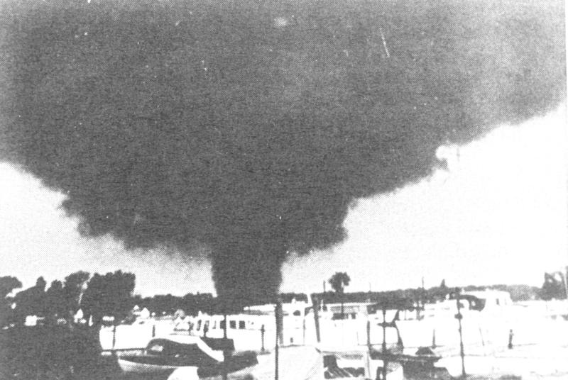
The Candlestick Park tornado was an extremely violent F5 tornado that tracked over 200 miles in the states of Alabama and Mississippi. The tornado first formed in Hinds County in Mississippi at around 4PM Central Time and traveled 202.5 miles before dissipating just west of Tuscaloosa Alabama. throughout the state of Mississippi the storm caused an estimated $17 million in damages(1966 USD). The most severe damage took place at a shopping mall in Candlestick Park. Much of the building was completely leveled with only one wall left standing. Overall this tornado caused 58 deaths including 12 at the Candlestick Shopping Center in Jackson Mississippi.
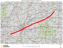
Official Track of the tornado
Courtesy of National Geographic
Courtesy of National Geographic
Super Outbreak
The second-largest and most violent tornado outbreak ever documented. Violent and deadly tornadoes, several of which were long lived, touched down over a wide area from Alabama to Indiana, affecting major population areas including Louisville,Cincinnati, and Huntsville. A violent F5 destroyed Brandenburg, Kentucky, and killed 31, and another F5 destroyed a large section of Xenia, Ohio, killing 32. Three F5s occurred in Alabama, including one of the strongest tornadoes on record, a long-tracked F5 that obliterated a large section of Guin, killing 28 people, 20 of them in Guin alone. Additionally, two other powerful F5s devastated the town of Tanner a half hour apart and killed total of 50 people. Numerous other violent, killer, long-tracked tornadoes occurred from the Great Lakes to the Gulf Coast, including an extremely long-tracked F4 that traveled almost 110 miles and killed 18 people in northern Indiana. Strong, deadly tornadoes occurred as far north as Ontario as well. The outbreak produced 30 violent tornadoes, 23 F4s and seven F5s
Total 148
F0 15
F1 37
F2 31
F3 35
F4 23
F5 7
Total 148
F0 15
F1 37
F2 31
F3 35
F4 23
F5 7
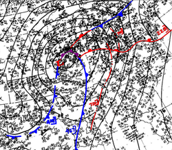
Surface analysis of the Storm System before the outbreak occurred.
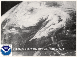
Super Outbreak storm system at its height.
1990 Plainfield Tornado
On August 28, 1990, a deadly and destructive tornado struck just outside of Chicago. This tornado is the only F5 tornado to be recorded in August and is the only F5 tornado to strike the Chicago. As of 2014 there are no known videos or photographs of this tornado since it was heavily rain-wrapped.
Total 12
F0 4
F1 4
F2 2
F3 1
F4 0
F5 1
This tornado contributed greatly to the development the development of NEXRAD (Next Generation Radar) which contributed greatly to the ability of meteorologists to recognize tornadic activity. Where previous generations of radar could show only reflectivity data and no direct information on air flows (although tornadic supercells and tornadic signatures such as the hook echo and bounded weak echo region (BWER) were identifiable), NEXRAD contained the ability to detect the wind speed and direction inside the storm. The ability to see rotation inside a storm on both the microscale (tornadic) and mesoscale (supercellular) measurements has allowed forecasters to issue severe thunderstorm and tornado warnings in more timely fashion and with a higher probability of detection.

Damage in Plainfield after the tornado.
Courtesy of the Chicago Tribune
Courtesy of the Chicago Tribune
1991 Andover Kansas tornado outbreak
The Andover Kansas tornado outbreak was a violent outbreak of 55 tornadoes that struck the Great Plains killing 24 people and injuring hundreds more.On April 25, 1991, the National Severe Storms Forecast Center, now called the Storm Prediction Center, forecast a high risk of severe weather for the following day. A strong storm system was due to move through the area the next afternoon and evening of April 26, 1991
Haysville–McConnell AFB–Andover, Kansas tornado
This tornado reached a powerful F5 status and was the most destructive tornado of the entire outbreak. It is considered one of the most-filmed F5 tornadoes of all time, because by 1991, video camcorders were very popular and easily obtainable by the general public
It first produced extensive damage as it formed south of Clearwater, Kansas. It fluctuated in intensity near the beginning of the path, and then crossed I-35 and moved through the city of Haysville. Widespread damage was reported in Haysville with many structures destroyed, but there were no fatalities. On the east side of Haysville, the tornado expanded to around 300 feet wide as it crossed I-35 (the Kansas Turnpike) and headed toward McConnell Air Force Base. Many people had advance warning before the tornado struck McConnell AFB. The tornado struck the base school, hospital and housing as an F3 tornado. It caused $62 million in damage on the base, narrowly missing a multi-billion dollar line of B-1 bombers. The damage path widened dramatically as the tornado intensified just east-northeast of the base.
By 6:35 p.m., the tornado had expanded to just over 600 yards wide and was approaching maximum intensity. It continued to move northeast and reached F5 intensity as it tore through the town of Andover, Kansas. Thirteen people were killed as the Golden Spur Mobile Home Park was obliterated, with little left there but scattered debris and twisted mobile home frames. The death toll included a father and son who abandoned their car and sought shelter in a ditch nearby. Extensive debris rowing and grass scouring was noted as the tornado swept well-constructed homes from their foundations just west of N Andover Road as the tornado passed through densely populated residential areas. Vehicles were thrown nearly a mile from where they originated, and trees in the area were debarked. One vehicle that originated at the Golden Spur mobile home park was thrown 3/4 of a mile, and was so thoroughly mangled that surveyors could not determine if it was a car or a truck.[7] The tornado then veered north, missing a Girl Scout camp where summer camp training was being conducted and a troop campout. The tornado then moved on to the northeast, passing just south of Towanda. The damage in this area was rated at F4 intensity as additional well-built homes were leveled. The tornado continued northeast and reached El Dorado Lake just before 7pm (CST). Video taken by local storm chasers shows that the tornado crossed over the lake and revealed a multiple vortex structure. Just after crossing over the lake to the northeast, the circulation dissipated and died out. The Andover tornado had traveled for nearly 46 miles, and was on the ground for over an hour.
This was the last F5 tornado recorded in Kansas under the old Fujita scale. The next tornado of such intensity, an EF5 on the newer Enhanced Fujita scale, wouldn't be reported until 16 years later on May 4, 2007, in Greensburg, Kiowa County, about 120 miles west of the path of the 1991 tornado. Since February 1, 2007, the National Weather Servicehas used the Enhanced Fujita scale.
Total 55
F0 12
F1 13
F2 18
F3 7
F4 4
F5 1
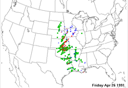
SPC storm reports in April 26 1991. The red dots are tornadoes,the green dots are hail while the blue dots are Damaging Winds

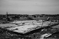
Extreme damage after the tornado hit Andover Kansas just outside of Wichita Kansas
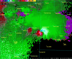
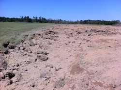
1997 jarrell Texas tornado
This tornado outbreak was an unusual tornado outbreak that affected the area between the cities of Austin and Dallas Texas. At the height of the outbreak, an F5 tornado ripped through the down of Jarrell Texas. Double Creek Estates a subdivision of Jarrell was literally wiped off the face of the earth with the entire neighborhood completely obliterated.
The Jarrell Tornado was an F5 tornado that was initially a weak pencil like tornado, but extremely favorable conditions allowed the tornado to expand into a 3/4 mile wide Wedge Tornado.Its first damage occurred three minutes later at 3:48 pm CDT in the northwestern portion of Jarrell striking Double Creek Estates, sweeping away the entire neighborhood. It moved to the south-west, which is unusual for tornadoes in North America. It later entered a wooded area before dissipating after damaging numerous trees. Normally when a thunderstorm is rotating it will show a "hook echo" which is a sign that the storm is rotating. The Jarrell storm Did not show a "hook" on the radar signature; also intense ground scouring occurred at a depth of 18 inched transforming a field of grass and literally turning it into mud
There were 27 fatalities in this outbreak.
A foundation of a house wiped clean after the tornado.
Video of the Jarrell TX Tornado Courtesy of Gabriel Cox
1999 Oklahoma Tornado Outbreak
From May 2-3, a vigorous severe weather event took place across the central and parts of the eastern united states. During this week long event,152 tornadoes touched down including one in Canada. more than half of those touched down on May 2-3 alone. The most notorious tornado spawned near Chickasha Oklahoma and became an F5 on the fujita scale before dissipating near Midwest city. The tornado ripped through the communities of Bridge Creek and Moore causing over $1 billion in damages making this tornado one of the costliest on record although not the deadliest.
The Bridge Creek-Moore F5
Ground zero for this outbreak was this tornado which was an extremely powerful F5 tornado that had the highest wind speed ever recorded at 301 MPH(484 KM/H). Throughout it's hour and 25 minute existence the tornado covered a total of 38 miles, destroying thousands of homes, killing 36 people(plus five indirect).
The tornado initially touched down at 6:23pm CDT in Grady County and it quickly intensified in to a violent F4 tornado and gradually strengthened to reach F5 status after traveling nearly 7 miles after which it struck the town of Bridge Creek. After it moved through Bridge Creek, it fluctuated between F2 and F5 status. As it approached the city of Moore, Oklahoma, it restrengthened and became an F5 for a third time obliterating everything in its path. by 7:30pm CDT the tornado crossed into southern Oklahoma county and battered southern Oklahoma city before dissipating as an F3 at 7:48pm. In total the tornado destroyed nearly 10,000 structures.
In the wake of the tornado, search and rescue teams were deployed including the United States National Guard. President Bill Clinton signed a federal disaster declaration for the area allowing Oklahoma to receive federal aid. In the following months relief efforts topped to $67.8 million. In the wake of the five fatalities that occurred in overpasses, the belief that overpasses were the safest places to be during a tornado was dismissed and they were considered to be one of the most dangerous area to be when a tornado hits. Reconstruction efforts in the following years led to a more tornado-hardened community. In May of 2013, 14 years after the 1999 tornado Moore was again struck by an extremely intense EF5 tornado, but despite the similar structure damage there were fewer fatalities.
The Bridge Creek–Moore tornado was part of a much larger outbreak, which spawned 71 tornadoes across five states on May 3 alone. On the morning of May 3, the Storm Prediction Center (SPC) issued a slight risk for severe weather later that day, as a dry line that stretched from western Kansas into western Texas approached a warm, humid air-mass over the Central Plains. Although cirrus clouds were present through much of the day, an eventual clearing allowed for the sun to heat up the moisture-laden region, creating significant atmospheric instability. By 7:00 a.m. CDT, CAPE values began exceeding 4,000 j/kg, a level which climatologically favors the development of severe thunderstorms. This prompted the SPC to upgrade the forecasted threat of severe weather to a moderate risk for much of central Oklahoma.
By the early afternoon hours, forecasters at both the SPC and the National Weather Service Weather Forecast Office in Norman, Oklahoma realized that a major event was likely to take place. Conditions became highly conductive for tornadic development by 1:00 p.m. CDT as wind shear intensified over the region, creating a highly unstable atmosphere.[4] At 3:49 p.m. CDT, a high risk of severe weather was issued by the Storm Prediction Center for much of central Oklahoma. Within minutes of this, the SPC issued a tornado watch for southern Kansas and the central two-thirds of Oklahoma just as supercells began developing over southwestern Oklahoma, prompting the issuance of a severe thunderstorm warning by 4:15 p.m. CDT
The thunderstorm that eventually spawned the F5 Bridge Creek–Moore tornado formed around 3:30 p.m. CDT over Tillman County. Tracking northeast, the storm strengthened and entered Comanche County shortly after 4:00 p.m. CDT. There, hail up to 1.75 inches in diameter fell; at 4:51 p.m. CDT, the first of 14 tornadoes associated with supercell "A" (the National Weather Service Weather Forecast Office in Norman designated lettered names for the three tornado-producing supercells in the outbreak in storm surveys) touched down along U.S. Route 62. Five more tornadoes touched down as the storm continued northeast; the sixth touchdown was an F3, which caused substantial damage in Grady County. At 6:23 p.m. CDT, the ninth tornado associated with supercell "A" touched down about 2 miles (3.2 km) south-southwest of Amber.
That tornado quickly intensified as it crossed Oklahoma State Highway 92, attaining F4 strength about 4 miles (6.4 km) east-northeast of Amber. Damage consistent with this rating was sustained over the following 6.5 miles (10.5 km) before striking Bridge Creek. There, it attained the highest-possible rating on the Fujita Scale, F5. Damage in this area was extreme, as many homes were completely destroyed, leaving only concrete slabs where the structures once were. Extensive ground scouring occurred, and vehicles were thrown hundreds of yards from where they originated, including a mangled pickup truck that was found wrapped around a telephone pole. It was in this area that a mobile Doppler weather Radar recorded winds of 301 mph (484 km/h) within the tornado, the highest wind speed ever recorded on earth. However, since the record for maximum winds are reported from only non-tornadic events, the 253 mph (407 km/h) wind gust from Cyclone Olivia in 1996 retained the title. About 1 inch (25 mm) of asphalt was torn off a road by the violent tornado. Approximately 200 mobile homes/houses were destroyed, and hundreds of other structures were damaged. The Ridgecrest Baptist Church in Bridge Creek was also destroyed. Twelve persons died in Bridge Creek, nine in mobile homes, and all fatalities and the majority of injuries were concentrated in the Willow Lake Addition, Southern Hills Addition, and Bridge Creek Estates, consisting mostly of mobile homes. 39 people were injured in the area as well. Continuing northeastward, the tornado briefly weakened to F4 status before becoming an F5 again as it neared the Grady-McClain County line, where a car was thrown roughly 0.25 mi (0.40 km), and a well-built home with anchor bolts was reduced to a bare slab. At this time, it had attained a width of 1 mile (1.6 km). Around 6:57 p.m. CDT, the National Weather Service Weather Forecast Office in Norman issued the first-ever Tornado Emergency for southern portions of the Oklahoma City metropolitan area.
Paralleling Interstate 44, the tornado moved into McClain County, where it crossed the highway twice at F4 intensity, killing a woman as she was blown out from an underpass where she was attempting to seek shelter. At 7:10 p.m. CDT, a satellite tornado touched down over an open field north of Newcastle; it was rated as an F0 due to lack of damage. Thirty-eight homes and 2 businesses were destroyed in McClain County, and 40 homes were damaged. Some of the homes were leveled at F4 intensity, and 17 people were injured. After crossing the Canadian River, the tornado entered Cleveland County and weakened to F2 intensity. By this time, it had entered the southern reaches of the Oklahoma City limits. Several minutes after entering the county, it re-attained F4 status, and then moved directly into the city of Moore, where the tornado reached F5 intensity for a third time. Some of the most severe damage took place in Cleveland County, especially in the city of Moore, where 11 people were killed and 293 others were injured. The tornado caused an estimated $450 million in damage across the county. The first area impacted in Cleveland County was the Country Place Estates subdivision, where 50 homes were damaged and one was completely swept away at F5 intensity, with only the foundation remaining. Several vehicles were picked up and tossed nearly 0.25 mi (0.40 km). According to local police, an airplane wing, believed to have been from an airport in Grady County, was found near Country Place Estates. Next, the powerful tornado struck the densely populated Eastlake Estates at F5 intensity, killing three people and reducing entire rows of homes to rubble. In one instance, four adjacent homes were completely destroyed, with only concrete slabs remaining, warranting an F5 rating at that location. Three other homes in this housing division also received F5 damage, with the remaining destruction rated high-end F4. Severe debarking of trees was noted in this area. At the Emerald Springs Apartments, three more people were killed and a two-story apartment building was mostly flattened.
Just outside the Eastlake Estates, a ceremony at Westmoore High School was being held at the time of the tornado; however, adequate warning time allowed those at the school to seek shelter and no injures took place at the ceremony. Ultimately, Westmoore High sustained heavy damage and dozens of cars in the parking lot were tossed around, many of which were destroyed. The tornado proceeded through additional densely populated areas of Moore shortly thereafter, where several large groups of homes were flattened in residential areas, with a mixture of high end F4 and low end F5 damage noted. Near Janeway Avenue, four people were killed in an area where multiple homes were completely destroyed. A woman was also killed when she was blown out from under the Shields overpass of Interstate 35. The tornado weakened somewhat as it moved through the Highland Park area, but still caused widespread F3 and F4 damage.
The first area impacted within Oklahoma County was an industrial district where the tornado re-intensified to F4 strength and two people were killed. A trucking company was completely destroyed. A freight car, weighing 36,000 lb (16,000 kg) was thrown 0.75 mi (1.21 km). The car bounced as it traveled, remaining airborne for 50 to 100 yd (46 to 91 m) at a time. Crossing SE 44th into Del City, the tornado moved through the highly populated Del Aire housing addition, killing 6 persons and damaging or destroying hundreds of homes, with many sustaining F3 to F4 damage. Seven people were killed as a direct result of the tornado in Del City, and hundreds of homes were damaged or destroyed.The tornado then crossed Sooner Rd., damaged an entry gate and several buildings at Tinker Air Force Base, then crossed 29th St. into Midwest City, destroying 1 building at the Boeing Complex and damaging 2 others. Widespread F3/F4 damage continued as the tornado moved across Interstate 40 affecting a large business district. Approximately 800 vehicles were damaged at Hudiburg Auto Group, located just south of Interstate 40. Hundreds of the vehicles were moved from their original location, and dozens of vehicles were picked up and tossed northward across Interstate 40 into several motels, a distance of approximately 2 tenths of a mile. Numerous motels and other businesses including Hampton Inn, Comfort Inn, Inn Suites, Clarion Inn, Cracker Barrel, and portions of Rose State College, were destroyed. Some of the damage through this area was rated high F4, however low F5 was considered. The tornado then continued into another residential area located between SE 15th and Reno Ave, where 3 fatalities occurred. High F4 damage was inflicted to 4 homes in this area. Two of these homes were located between SE 12th and SE 11th, near Buena Vista, and the other 2 homes were located on Will Rogers Rd. just south of SE 15th. Damage then diminished rapidly to F0/F1 strength as the tornado crossed Reno Ave. before dissipating 3 blocks north of Reno Ave. between Sooner Rd. and Air Depot Blvd. Throughout Oklahoma County, 12 people were killed and 234 others were injured while losses amounted to $450 million.
Throughout the tornado's path, 36 people were killed as a direct result of the storm and five more died in the hours following it. According to the Oklahoma Department of Health, an estimated 583 people were injured by the tornado, accounting for those who likely did not go to the hospital or were unaccounted for. In terms of structural losses, a total of 8,132 homes, 1,041 apartments, 260 businesses, 11 public buildings and seven churches were damaged or destroyed
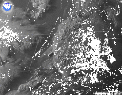
Satellite image of the storms exploding over Oklahoma.
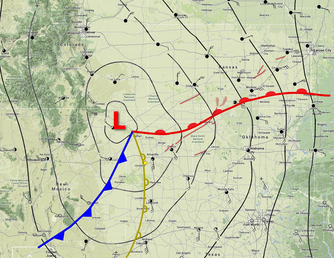
May 2007 tornado outbreak
This tornado outbreak was an extended tornado outbreak that affected mainly the Great Plains. The most destructive tornado occurred on the evening of May 4 where an EF5 devastated Greensburg Kansas. The storm killed at least 13 people including 11 in Greensburg. At least 60 people were injured in Greensburg. This tornado is the first tornado to be rated EF5 on the Enhanced Fujita Scale
This severe weather outbreak can be traced back to a powerful, slow-moving low pressure area with a warm front to the north over Nebraska and Missouri. On May 4, the low stalled over the High Plains and additional moisture coming from the Gulf of Mexico moved in behind the warm front and increased amounts of instability across much of the region, with CAPE values as high as 5,500 J/kg. In addition, the dry line, which marks a divided line between the dry and humid air mass, was positioned over the southern High Plains. This allowed for the initiation of scattered supercells on May 4. High wind shear also allowed for intense rotation in the atmosphere. All the ingredients were present for the developing of supercell thunderstorms producing damaging wind, large hail and tornadoes.
The Storm Prediction Center issued a moderate risk for severe weather across western Kansas and small portions of Oklahoma, Colorado and Nebraska for May 4, while temperatures were in the mid to high 80s°F (near 30°C). The atmosphere remained capped for much of the day, but storms began to develop in the late afternoon hours in western Oklahoma and the eastern Texas Panhandle. The strongest supercells developed in the early evening hours across northwestern Oklahoma and southwestern Kansas. They eventually produced 25 tornadoes, including the devastating Greensburg tornado and three other extremely large tornadoes which followed the Greensburg tornado late that evening. The supercells remained intact well into the overnight hours as the extremely unstable air mass precluded rapid dissipation expected with the loss of daytime heating which would normally be expected in the Plains. The last tornado of the night did not lift until shortly after 2:00 a.m. early on May 5.
On May 5, the SPC issued a high risk of severe weather for Central Kansas and central Nebraska, while moderate and slight risks for severe weather extended for areas far beyond. The low pressure system in place moved northward, but the extending front had barely moved. The storms were quick to develop. Severe weather reports were already coming in by late morning, and the first tornado reports came in during the early afternoon hours. The most intense activity took place during the late afternoon and evening hours as supercells developed along a long line from South Dakota to North Texas. Over 80 tornadoes were confirmed that day, along with hail as large as softballs and straight–line winds as strong as 90 mph. The activity weakened in the late evening, but not before the last tornadoes were reported in Iowa in the overnight hours.
The low gradually weakened and became less conducive for severe weather development on May 6. Nonetheless, the SPC issued a moderate risk for severe storms over parts of central Kansas and northern Oklahoma as the trough remained in place. The activity was far less than on the two previous days, however there were still several additional tornadoes across the Plains (all of them weak, mostly EF0). The system finally left the area on May 7 and did not produce any more significant severe weather
Total 123
EF0 62
EF1 43
EF2 15
EF3 5
EF4 0
EF5 1
*Note the National Weather Service began using the Enhanced Fujita Scale starting February 1, 2007
Radar Shot of the tornado shortly before striking Greensburg.
Red is outbound while green is inbound.
Red is outbound while green is inbound.
April 25-28, 2011 Tornado Outbreak
This outbreak was the largest and one of the deadliest outbreaks on record. Affecting the Midwest, Southern, and the Northeastern states and leaving catastrophic damage along it's wake. This outbreak produced deadly and destructive tornadoes in Alabama Mississippi and Georgia and affected many other areas on the eastern seaboard. April 27 was the most active tornadic day on record with 211 tornadoes while four of the tornadoes were destructive enough to be rated EF5 on the Enhanced Fujita Scale, which is the highest rating. April 27 had the most tornado-related fatalities in the United States in a single day since the "Tri-State" outbreak on March 18, 1925, when at least 747 people were killed. Nearly 500 preliminary local storm reports were received for tornadoes over four days, including 292 in 16 states on April 27 alone. This event was the costliest tornado outbreak and one of the costliest natural disasters in United States history (even after adjustments for inflation), with total damages of approximately $11 billion (2011 USD).
The outbreak was caused by a vigorous upper-level trough that moved into the Southern Plains states on April 25. An extratropical cyclone developed ahead of this upper-level trough between northeastern Oklahoma and western Missouri, which moved northeast. Conditions were similar on April 26, with a predicted likelihood of severe thunderstorms, including an extended threat of strong to violent long-track tornadoes during the afternoon and evening hours; mixed-layer CAPE values were forecast to be around 3000–4000 J/kg, around east Texas, Louisiana and Arkansas. The storm mode on April 26 was predicted to consist of mostly discrete supercells during the afternoon and early evening, shifting over to a mesoscale convective complex, with more of a threat of damaging winds and hail during the nighttime hours.
As the storm system moved eastward toward the Ohio, Mississippi and Tennessee Valleys on April 27, a very powerful 80–100 knot mid-level jet stream moved into the Ohio and Tennessee Valleys, behind the trough, creating strong wind shear, with a low pressure center moving quickly northeastward across those areas on the 27th. On the afternoon of April 27, CAPE values were estimated to be in the range of 2000–3000 J/kg across Louisiana and southern Mississippi, with the moderate instability moving northeastward across the southern Tennessee Valley; in addition, temperatures across the southeastern United States ranged from the 70s °F (mid-20s °C) to the lower 90s °F (near 35 °C). Helicity levels ranged from 450–600 m2/s2, which were supportive for significant tornadic activity and strong to violent long-track tornadoes.
April 25
A large area of possible severe storms for April 25–27 was forecast as the Storm Prediction Center (SPC) issued a moderate risk of severe weather for three consecutive days, centered over Arkansas through Tennessee. By the late-afternoon hours of April 25, several tornadoes had been reported across a few states, including two which caused significant damage in Oklahoma and Texas. At 3:25 p.m. CDT , the SPC issued a Particularly dangerous situation (PDS) tornado watch for much of Arkansas and parts of Missouri, Oklahoma, Texas and Louisiana. Tornadoes were scattered that day until early evening, when an intense tornadic cell (a supercell that has produced or is capable of producing a tornado) tracked near the Little Rock metropolitan area and a tornado emergency was declared for Vilonia, Arkansas. A large EF2 wedge tornado struck the town, causing severe damage and killing four people. A strong EF3 tornado also struck Hot Springs Village that evening, causing severe damage and one death. Another tornado caused extensive damage to Little Rock Air Force Base. Severe flooding continued across a large area from the Red River valley to the Great Lakes.
April 26
A high risk of severe weather was issued for April 26 for portions of Louisiana, Arkansas, Oklahoma and Texas along and near the Interstate 30 corridor as conditions became even more favorable for extreme weather. A large PDS tornado watch with very high tornado probabilities was issued that afternoon for that same area. Widespread tornado warnings were issued in that area later that evening.
Tornado watches were also issued for the Lower Great Lakes in the afternoon hours, and supercells began to track across southern Michigan in the early evening. Two tornadoes touched down in Michigan and caused damage to farm structures. Further east, severe thunderstorms caused scattered wind damage and large hail across Pennsylvania and New York. Two-inch-diameter hail was reported in Lock Haven, Pennsylvania. An isolated supercell moved across Central New York throughout much of the afternoon, producing golf ball-sized hail in Syracuse, and spawned a very brief EF1 tornado in Verona Mills, causing primarily tree damage. Another tornado in Gilbertsville caused significant damage to an athletic field at a school.
Numerous tornadoes touched down across Texas, Louisiana, Arkansas, and several other states. Most of the tornadoes were weak, but a few caused considerable damage. A long-track wedge tornado caused EF2 damage across Texas and Louisiana. An EF3 tornado destroyed multiple structures and caused severe damage at Fort Campbell, Kentucky.
April 27
For the second day in a row, the SPC issued a high risk of severe weather for the Southern United States, and late that morning the SPC increased the probability for tornadoes to 45 percent along a corridor from Meridian, Mississippi to Huntsville, Alabama, an extremely rare issuance exceeding the high risk standards. Conditions for tornadoes became increasingly favorable for an extreme tornado outbreak.[34] Early in the morning, a squall line of severe thunderstorms packing straight-line winds and numerous embedded tornadoes affected North and Central Alabama and parts of Middle and East Tennessee. These storms knocked out power and telephone lines in a few areas; these outages would become much more widespread as the day continued. This preliminary line of storms also caused some NOAA weather radio transmitter sites to stop functioning for the remainder of the outbreak. As a result, many people had no warning of approaching tornadoes later in the day.
During the afternoon, a tornado emergency was declared for Neshoba County, Mississippi as a large tornado was reported on the ground by storm spotters and a camera atop a television tower from ABC affiliate WTOK-TV (channel 11) in Meridian, Mississippi. This powerful EF5 tornado caused incredible damage near Philadelphia, Mississippi where homes were swept away, vehicles were thrown, and the ground was scoured out to a depth of 2 feet (0.61 m) by the tornado. Three people died in this tornado when a mobile home was picked up, thrown into a wooded area, and destroyed. The atmosphere became increasingly unstable throughout the late afternoon, causing more explosive supercell development. A widespread complex of supercell storms overspread the states of Mississippi and Alabama and violent tornadoes began rapidly touching down as the evening progressed. Four tornadoes were officially rated as EF5 on the Enhanced Fujita scale that day. These tornadoes affected several counties in the states of Mississippi and Alabama, especially the towns of Smithville, Mississippi; Hackleburg and Phil Campbell, Alabama; Philadelphia, Mississippi; and Rainsville, Alabama. This marks only the second day in history (the other being the April 3, 1974 Super Outbreak) that there were more than two F5/EF5 tornadoes
April 28
Tornado watches were issued for the Atlantic coast from Pennsylvania to Florida at the start of the day and continued through the morning and early afternoon, but tornadoes were forecasted to generally be weaker and more isolated. Even so, several people were killed across the region and tornadoes were reported in Pennsylvania, New York, Virginia, North Carolina, South Carolina, Georgia, Florida, and Maryland. Although tornado watches were issued, no tornadoes were spotted in New Jersey or Washington, D.C. In the wake of the tornadoes and severe thunderstorms, widespread flooding hit the Midwest, South, and Eastern Seaboard, with extensive flood and flash flood warnings issued. One particularly damaging and deadly EF3 tornado struck the town of Glade Spring, Virginia very early in the morning, where three people died. Other strong tornadoes caused severe damage and a few fatalities in Georgia during the early morning hours. The last tornadoes of the outbreak touched down that afternoon in eastern North Carolina, which was hard hit in the April 16 outbreak, but they were all weak this time. The system moved out into the Atlantic Ocean that evening, with the exception of isolated thunderstorms over central Florida that night into April 29, although there were no tornadoes then.
Total 358
EF0 129*
EF1 143
EF2 49
EF3 22
EF4 11
EF5 4
*One tornado touched down in Ontario Canada which was rated an F0, it is counted as an EF0 in this table
Intense ground scouring in Mississippi by an EF5 tornado
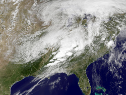
The storm system at it's peak. Note how expansive this system is.
